

Geotagging+

Beschreibung von Geotagging+
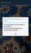
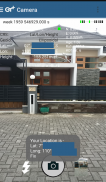
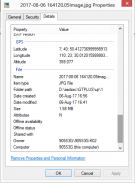
This app allows you to take image and measure with low-cost GNSS module (like U-blox GNSS module or E-GNSS from potretudara : http://www.potretudara.com/low-cost-gps-gis/ ). Measured coordinates from low-cost GNSS module are stored to EXIF image metadata in time when you tap the "capture" button. Use this to create your geotagging more precise to sub-meter level. Very useful for census, GIS support, reporting issue, and others.
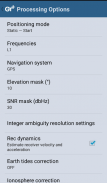
You can still use internal GNSS for geotagging by deactivate BASE and ROVER in the Input Stream menu. Obviously none of the precision algorithm found in RTKLIB can be use.
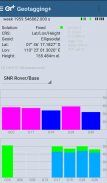
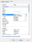
Image taken by this app will have coordinate metadata, accuracy, and solution type (internal, single, float, or fix).
Heavily based on RtkGps+ from Ronan LE MEILLAT, this is a fork of his work. Original licenses are in the "About/Legacy Info" screen. Thanks to all contributors to respect this clause.
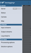
This app is RTKGPS+-like with additional Camera menu. You still can use this app for surveying, tracking, etc. like RTKGPS+ do.
This app is a port of RTKLIB 2.4.3b 28 developed by Tomoji Takasu (http://http://www.rtklib.com/). This RTKLIB 2.4.3 is modified by rtklibexplorer and named RTKLIB 2.4.3 demo 5 b 28 (https://github.com/rtklibexplorer/RTKLIB). If you do not know what this application is, this application is probably not what you are looking for!
App manual : http://bit.ly/shortmanual
Diese App ermöglicht es Ihnen, ein Bild aufzunehmen und mit Low-Cost-GNSS-Modul (wie U-blox GPS-Moduls oder E-GNSS von potretudara: http://www.potretudara.com/low-cost-gps-gis/) zu messen. Gemessene Koordinaten von Low-Cost GNSS-Modul sind EXIF Bildmetadaten in der Zeit gespeichert, wenn Sie die „Capture“ Taste tippen. Verwenden Sie diese Ihre Geotagging genauer Unter-Meter-Ebene zu schaffen. Sehr nützlich für die Volkszählung, GIS-Unterstützung, Reporting Ausgabe und andere.
Sie können immer noch internen GNSS verwenden für durch deactivate Basis und Rover im Input Stream Menü Geotagging. Offensichtlich keine der Präzision Algorithmus in RTKLIB finden kann nützlich sein.
Bild von dieser App genommen haben Metadaten koordinieren, Genauigkeit und Lösungstyp (intern, Single, Schwimmer oder fix).
Stark auf RtkGps + von Ronan LE MEILLAT, ist dies eine Gabel seiner Arbeit. Original-Lizenzen sind in der "About / Legacy-Info" -Bildschirm. Dank an alle Mitwirkenden, diese Klausel zu respektieren.
Diese App ist RTKGPS + -ähnlichen mit zusätzlichem Kamera-Menü. Sie können immer noch diese App für Vermessung verwenden, Tracking etc. wie RTKGPS + tun.
Diese App ist eine Portierung von RTKLIB 2.4.3b 28 entwickelt von Tomoji Takasu (http: // http: //www.rtklib.com/). Diese RTKLIB 2.4.3 wird durch rtklibexplorer modifiziert und RTKLIB 2.4.3 Demo 5 b 28 (https://github.com/rtklibexplorer/RTKLIB) benannt. Wenn Sie nicht wissen, was diese Anwendung ist, ist diese Anwendung wahrscheinlich nicht das, was Sie suchen!
App Handbuch: http://bit.ly/shortmanual


